[
Date Prev][
Date Next][
Thread Prev][
Thread Next][
Date Index][
Thread Index]
[
List Home]
|
[udig-users] Setting sub area of raster layers for processing
|
Greetings. In uDig v 1.4.0b is there a
way to interactively set the area of processing to perform calculations
via OmsMapCalc for a sub region in two raster layers of different resolution
(2km and 1/9 arc sec). There are no parent vector files in the layer
list.
We have searched on line and in the
archives and am unable to recognize a similar solution. Nor does
it appear this is intrinsically possible via Selection Tool via Box Selection
or AOI selection sans shape file layer.
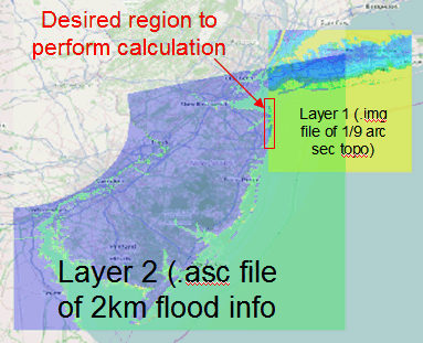
Details (see small image attached)
Layer 1 = image file of topography 1/9
arc sec resolution over a small geographic area
Layer 2 = 2km raster of flood water
height from a hurricane (overlaps but does not contain fully the geographic
and smaller area of layer #1)
We wish to process data in a small overlapping
region of the two layers (simple layer 2 minus layer 1 calculation) --
not the entire region of layer 1 or layer 2
Pete
-----------------------------------------
The information contained in this message is intended only for the
personal and confidential use of the recipient(s) named above. If
the reader of this message is not the intended recipient or an
agent responsible for delivering it to the intended recipient, you
are hereby notified that you have received this document in error
and that any review, dissemination, distribution, or copying of
this message is strictly prohibited. If you have received this
communication in error, please notify us immediately, and delete
the original message.