[
Date Prev][
Date Next][
Thread Prev][
Thread Next][
Date Index][
Thread Index]
[
List Home]
|
Re: [udig-users] Some uDIG use issues
|
Shaun Kolomeitz wrote:
Thanks Jody,

I'll have to monitor what I do carefully so I can ask "what the?" type
questions and describe the scenario more fully.

I can't see (logically) how to add/edit multi-part shapes. Do you trace
one and hold the shift or control key down for the others ??? Yes I have
turned the "Advanced Editing" on, but there doesn't seem to be any
additional tools added (should there be?).
No; it is more that the existing tools let you do more things; as an
example you can add new points around the edge of a polygon when
editing, just click on the edge and a point will be created (no need to
switch to the "Add Vertex" tool). I know you can select multiple
polygons that overlap; something like holding down a key while clicking
in the same location ...
I quite obviously have not documented this sort of thing (as I was not
interested until uDig 1.1.0 went out).
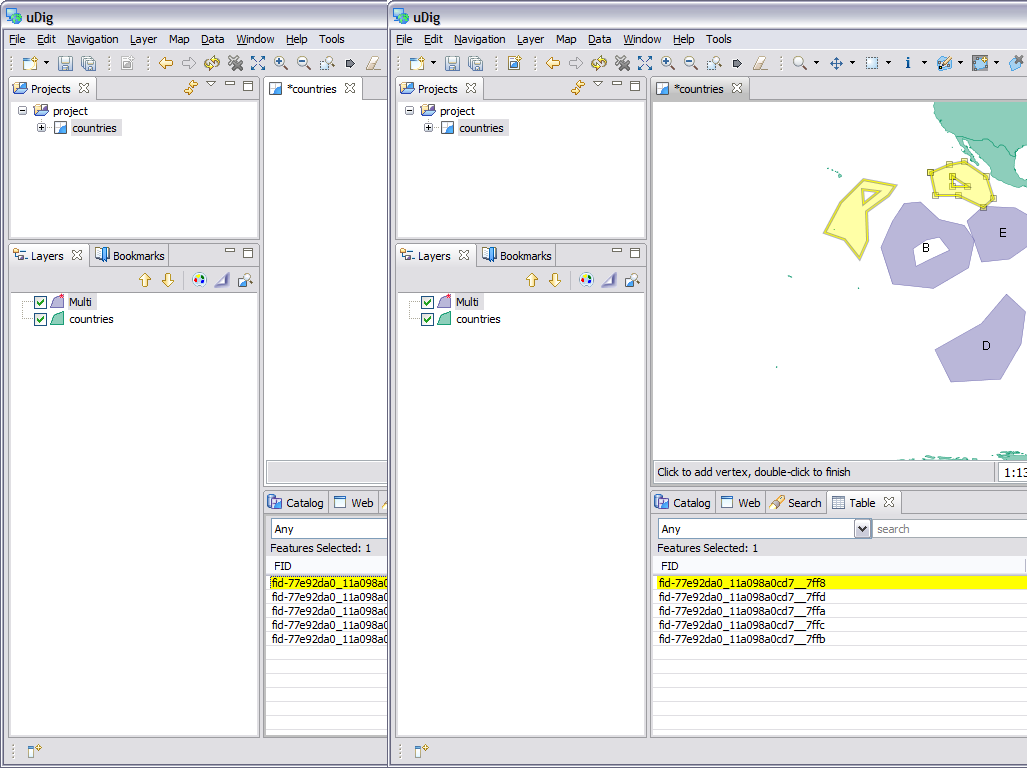
Okay; tunning on "advanced tools" and restarting udig lets me add
additional polygons.
1. create a polygon like normal (using the create polygon tools which is
selected in the attached screen snap)
2. hold down SHIFT to create additional polygons
3. use the hole tool in any of the created polygons
What I am trying to do is (for example) add a "set of points" as a single shape record (I don't
want to mix shape types). This could be a distribution record for a weed. We do them as groups to simplify the workflow. We do a similar thing for Burn Proposals (Planned Burns) where the users add a number of polygon as one shape (ie. A multipolygon) record.
Okay I understand.
I have in my mind that we would use external services like WMS/WFS to provide core datasets like park boundaries, contours, etc via GeoServer. I can send you an example of the data if that would help (it's a very wide shapefile with 200 columns or so).
No need to send me the data; I have examples (and GeoServer) locally.
Note that the WMS / WFS solution only make sense when there is a good
internet connection ;-)
It is this way to cater for a relational set of data within one table. I went thru the old walkthrough 2 (dated Nov 2006) and have had a flick thru the Jan 2008 one (ie I haven't done it tho). I can't see a reference to adding a multipart shape (except via a copy/paste from the Tassie example).
You are correct; walkthrough 2 only covers some basics.
I haven't seen the Axios editing tools so I'd need to look at how to install these.
The instructions are in the online help last I checked .. here is the
community page:
-
http://udig.refractions.net/confluence/display/COM/Spatial+Operations+and+Editing+Tools
As far as forms go we would have something of the order of 20 - 30 forms, so going on your suggestion we would do these as vanilla flavoured Java forms (JWT?).
SWT (ie standard widget toolkit); yes this would be my recommendation
for a short term project.
All the best,
Jody