Hello,
The GeoMesa raster library has not seen much adoption, and it is
currently unmaintained. As such, we've marked it as deprecated and
plan to remove it in our next major release. If you're interested in
helping maintain it, please let us know. Otherwise, I would suggest
switching to postgis for tile persistence: http://docs.geotools.org/latest/userguide/library/coverage/pgraster.html
Thanks,
Emilio
On 8/9/19 6:37 AM, 张黎 wrote:
Hi:
I have solved garbled code
problem by editing
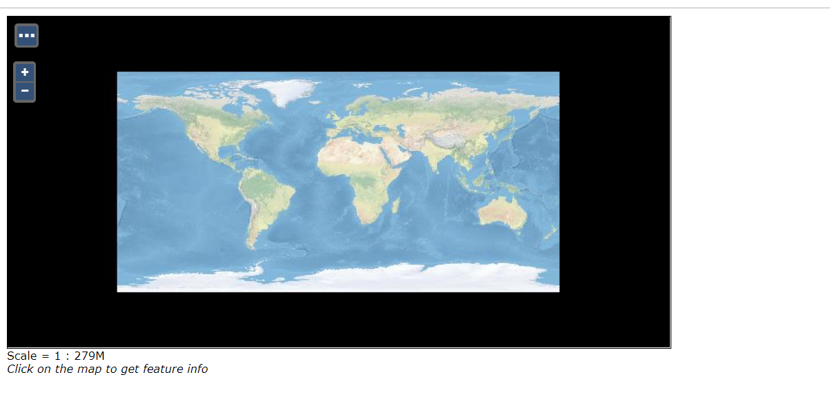
geotools ShapefileDataStoreFactory.class.But Now,I find two other problem.When I ingest raster data
and finished
the process.It's
OK.Like this:
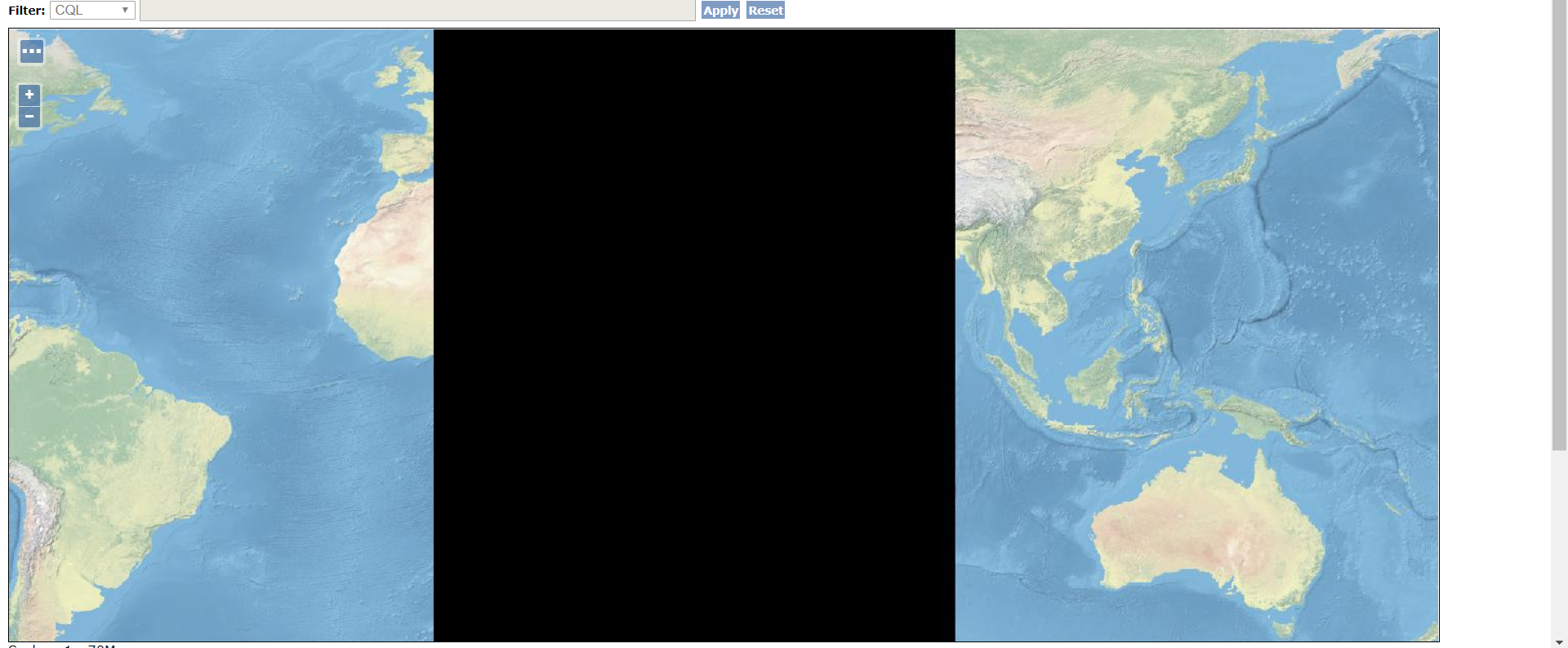
But
when I zoom
in the Map,In some zoom level,it
lost some tiles.Like this:
If I
publish Layer Groups, When I zoom
in the Map , In
some zoom level ,it Can't overlap.
Can you tell me what happened.
At 2019-07-31 18:36:13, "张黎" <zliprogram@xxxxxxx> wrote:
Hi:
Thank you for contacting me.I will try
to to use the geotools API to write the
features directly.I wish the ticket can be solve as
soon as possible.You are so kind.
At 2019-07-31 00:03:56, "Emilio Lahr-Vivaz"
<elahrvivaz@xxxxxxxx> wrote:
Hello,
I created a ticket to support ingesting shapefiles with
different charsets: https://geomesa.atlassian.net/browse/GEOMESA-2679
As a work-around, if you can export your data as CSV or
JSON, you should be able to ingest that as UTF-8.
Alternatively, you should be able to use the geotools API
to write the features directly, but you won't be able to
use the geomesa CLI tools.
Thanks,
Emilio
On 7/30/19 11:47 AM, 张黎
wrote:
Hi:
Yes,I ingest a shapefile using the GeoMesa CLI
tools and the command is
“geomesa-accumulo ingest --catalog qgzhd
--feature-name qgzhd --input-format shp
"/mnt/data/qgzhd/qgzhd.shp" -u root -p root -z
master:2181,slave1:2181,slave2:2181 -i
accumulo“,it is successful. I think the reason
why the data is being garbled is geoserver read
the data which use US-ASCII.of course,maybe the
issue is in the ingestion process.But I can not
change the CLI.
Thanks,
At 2019-07-30 21:16:14, "Emilio Lahr-Vivaz" <elahrvivaz@xxxxxxxx>
wrote:
Hello,
There is no GeoMesa configuration for character set,
as all data is treated as UTF-8. How exactly are you
ingesting the data into GeoMesa? I would guess that
the issue is in the ingestion process. If you are
ingesting from a shapefile using the GeoMesa CLI
tools, we don't currently expose the shapefile DBF
encoding, so that might be where the data is being
garbled.
Thanks,
Emilio
On 7/30/19 8:34 AM, 张黎
wrote:
Hi:
I ingesting
raster and vector data,If I publish the vector
data using Shapefiles , I can choose DBF
character as UTF-8,that is ok.But when I
Choose the DBF character as US-ASCII,The garbled the same as before.I think that
geoserver decode the character using
US-ASCII instead of UTF-8.But when I publish
the vector using Accumulo (GeoMesa),there are
no place to choose DBF character,I was
confused.
Shapefiles:
![]()
Accumulo (GeoMesa):
![]()
At 2019-07-30 20:15:13, "Emilio Lahr-Vivaz" <elahrvivaz@xxxxxxxx>
wrote:
Hello,
You're probably seeing the underlying bytes -
the shell isn't interpreting them as UTF, but
if you read them back out programmatically you
could do so.
Thanks,
Emilio
On 7/29/19 10:49
PM, 张黎 wrote:
Hi,
Maybe the Accumulo can not support
Chinese. I try to
use the accumulo shell to inspecte
tables.I find I can insert english,But
When I insert Chinese,I see some
garbled in shell .![]()
Now,I want to know how to set Accumulo
character .After all,the GeoMesa and
Geoserver support UTF-8.
At 2019-07-29 23:24:45, "Emilio
Lahr-Vivaz" <elahrvivaz@xxxxxxxx>
wrote:
Hello,
Are you ingesting raster or vector data,
or both? How exactly are you ingesting
your data?
Generally, GeoMesa stores everything as
UTF-8, which supports Chinese.
Thanks,
Emilio
On 7/29/19
11:11 AM, 张黎 wrote:
Dear Sir
or Madam:
I
want to publish raster
data using geoserver and
Geomesa-Accumulo,But two major problems
were encountered.The first,
I see
some garbled in map,like
this
How can I display
Chinese characters?Dose
Accumulo not supporte the
Chinese?
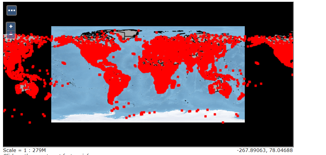
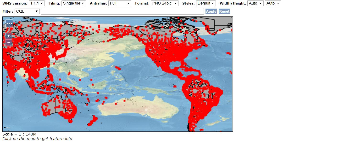
The second,When I
ingest raster data with
Geomesa-Accumulo and publish
the raster data with GeoServer
. the features is
disappeared,all the features
value is 0,like this:
But If I ingest
raster data without
Geomesa-Accumulo and publish
the raster data with
GeoServer, I can see the
features value. I do not know
what happen.
Due to the
short timeframe for this
proposal, prompt reply is
greatly appreciated.
_______________________________________________
geomesa-users mailing list
geomesa-users@xxxxxxxxxxxxxxxx
To change your delivery options, retrieve your password, or unsubscribe from this list, visit
https://dev.locationtech.org/mailman/listinfo/geomesa-users
_______________________________________________
geomesa-users mailing list
geomesa-users@xxxxxxxxxxxxxxxx
To change your delivery options, retrieve your password, or unsubscribe from this list, visit
https://dev.locationtech.org/mailman/listinfo/geomesa-users
_______________________________________________
geomesa-users mailing list
geomesa-users@xxxxxxxxxxxxxxxx
To change your delivery options, retrieve your password, or unsubscribe from this list, visit
https://dev.locationtech.org/mailman/listinfo/geomesa-users
_______________________________________________
geomesa-users mailing list
geomesa-users@xxxxxxxxxxxxxxxx
To change your delivery options, retrieve your password, or unsubscribe from this list, visit
https://dev.locationtech.org/mailman/listinfo/geomesa-users
_______________________________________________
geomesa-users mailing list
geomesa-users@xxxxxxxxxxxxxxxx
To change your delivery options, retrieve your password, or unsubscribe from this list, visit
https://dev.locationtech.org/mailman/listinfo/geomesa-users
|