Hello,
There is no GeoMesa configuration for character set, as all data is
treated as UTF-8. How exactly are you ingesting the data into
GeoMesa? I would guess that the issue is in the ingestion process.
If you are ingesting from a shapefile using the GeoMesa CLI tools,
we don't currently expose the shapefile DBF encoding, so that might
be where the data is being garbled.
Thanks,
Emilio
On 7/30/19 8:34 AM, 张黎 wrote:
Hi:
I ingesting raster and vector
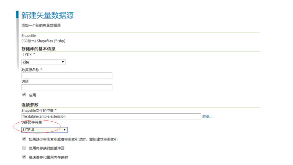
data,If I publish the vector data using Shapefiles , I can
choose DBF character as UTF-8,that is ok.But when I Choose
the DBF character as US-ASCII,The garbled the
same as before.I think that geoserver decode the character using
US-ASCII instead of UTF-8.But when I publish the vector
using Accumulo (GeoMesa),there are no place to choose DBF
character,I was confused.
Shapefiles:
Accumulo (GeoMesa):
![]()
At 2019-07-30 20:15:13, "Emilio Lahr-Vivaz"
<elahrvivaz@xxxxxxxx> wrote:
Hello,
You're probably seeing the underlying bytes - the shell isn't
interpreting them as UTF, but if you read them back out
programmatically you could do so.
Thanks,
Emilio
On 7/29/19 10:49 PM, 张黎 wrote:
Hi,
Maybe the Accumulo can not support Chinese. I try to use the accumulo shell to
inspecte tables.I find I can insert english,But When I
insert Chinese,I see some garbled in shell .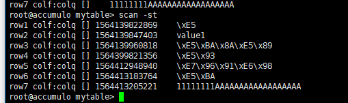
Now,I want to know how to set Accumulo character .After
all,the GeoMesa and Geoserver support UTF-8.
At 2019-07-29 23:24:45, "Emilio Lahr-Vivaz" <elahrvivaz@xxxxxxxx>
wrote:
Hello,
Are you ingesting raster or vector data, or both? How
exactly are you ingesting your data?
Generally, GeoMesa stores everything as UTF-8, which
supports Chinese.
Thanks,
Emilio
On 7/29/19 11:11 AM, 张黎
wrote:
Dear Sir or
Madam:
I want to publish raster data
using geoserver and Geomesa-Accumulo,But two major problems
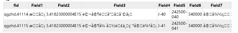
were encountered.The first, I see some garbled in map,like this
How can I display
Chinese characters?Dose Accumulo not supporte
the Chinese?
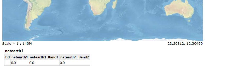
The second,When I
ingest raster data with Geomesa-Accumulo and
publish the raster data with GeoServer . the
features is disappeared,all the features value
is 0,like this:
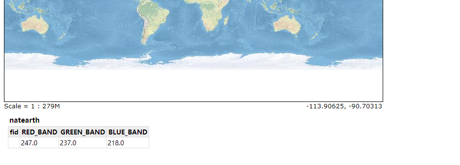
But If I ingest
raster data without Geomesa-Accumulo and
publish the raster data with GeoServer, I can
see the features value. I do not know what
happen.
Due to
the short timeframe for this proposal,
prompt reply is greatly appreciated.
_______________________________________________
geomesa-users mailing list
geomesa-users@xxxxxxxxxxxxxxxx
To change your delivery options, retrieve your password, or unsubscribe from this list, visit
https://dev.locationtech.org/mailman/listinfo/geomesa-users
_______________________________________________
geomesa-users mailing list
geomesa-users@xxxxxxxxxxxxxxxx
To change your delivery options, retrieve your password, or unsubscribe from this list, visit
https://dev.locationtech.org/mailman/listinfo/geomesa-users
_______________________________________________
geomesa-users mailing list
geomesa-users@xxxxxxxxxxxxxxxx
To change your delivery options, retrieve your password, or unsubscribe from this list, visit
https://dev.locationtech.org/mailman/listinfo/geomesa-users
|